(VOVworld) – More than 140 maps published by western geographers, navigators and cartographers between the 16th and 19th century marked the Hoang Sa/Paracel islands on the world map. This is evidence of Vietnam’s sovereignty over this archipelago. VOV introduces a research by Doctor Tran Duc Anh Son, Deputy Director of the Da Nang Institute for Socio-Economic Development.
On these maps, Paracel was described as a long blade, stretching vertically off the coast of Vietnam. The northern end of the blade was often marked with a number of locations such as I. des baixos Cachina, I. da Pracell, I. de Pracel, Doa Tavaquero, Paracel Islands, Paracel, Paracels, Pracel, and Parcels. The southern end was marked with Pullo Sissir do Mar, which is Cu Lao Thu island in Binh Thuan province at present. The maritime area opposite these islands, which is Vietnam’s central coast, was named Costa da Paracel, Coste de Pracel or the coast of Hoang Sa.
Original maps of historical values
There are 6 sets of maps that confirm Vietnam’s sovereignty over Hoang Sa.
The Cabo Comorim, Japao, Moluco e Note in Atlas with 18 maps was drawn by Fernão Vaz Dourado of Portugal in 1571. It marked the northern end of Paracels islands with I. dex baixos Cachina (islands of the Giao Chi shoal) and the southern end with Pulo Sissi (Cu Lao Thu island). Between these two ends were a number of clearly identified islands including Pulo Campello (Cu Lao Cham island), Pulo Catão (Cu Lao Re island) and Pulo Cambi (Cu Lao Xanh island). The inshore land in parallel with Pracel was called Costa da Pracel.
The map drawn by Portuguese navigator Fernão Vaz Dourado in 1576 was published in 1843 and 1847. The drawing of Hoang Sa islands was called I. da Pracell, which encompassed Truong Sa archipelago but was distinguished with other islands: P. Champello (Cu Lao Cham island), P. Cotao (Cu Lao Re island) and P. Cambiz (Cu Lao Xanh island).
The map drawn by Dutch navigator Van Langren in 1595 was one of the first western maps that detailed Paracel islands. On this map, Hoang Sa was called I. de Pracel while the western coast in parallel with Hoang Sa was called Costa de Pracel.
The India Orientalis (East of India) was drawn by Jodocus Hondius I in 1613. On this map, Hoang Sa and Truong Sa islands were connected like a blade under the name Pracel. The coast opposite Pracel’s western part was called Costa de Pracel.
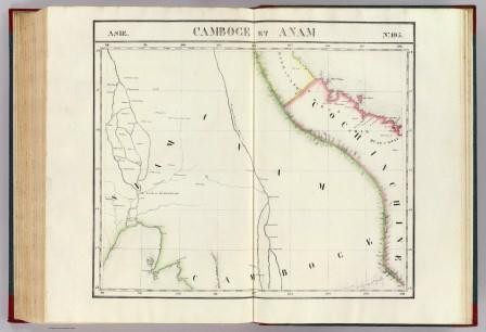
The map Partie de la Cochinchine is in the 6-volume World Atlas of Geography, which was compiled by Belgian geographer Philippe Vandermaelen and published in 1827 in Belgium. The map depicts Vietnam’s central coastline spanning from Latitudes 12 to 16, which included Kinh-Kang (Binh Khang the former name of Khanh Hoa province) with such locations as Carmraigne havre (Cam Ranh port) Nhiatrang (Nha Trang) and Quin-hone (Quy Nhon).
 |
Last but not least, the Great Annam Map was published by Bishop Jean-Louis Taberd in 1838. The name of the map was in classical Chinese, Esperanto, and Latin but the names of the locations on the map were written in Esperanto and Latin. The drawing of Hoang Sa islands on the map had the coordinates as exact as today with a caption “Paracel seu Cat vang” or “Paracel means golden sand”. In his article entitled “Note on the Geography of CochinChina” published in the Journal of the Asiatic Society of Bengal, volume 6, second part, 1837, Bishop Taberd wrote: “Paracel or Pracel which is Hoang Sa belongs to CochinChina (Vietnam at present)”.
Hoang Sa belongs to Vietnam
Names on ancient western maps demonstrate that since the 16th century Portuguese navigators pointed out the geographical links between the coast of CochinChina with Hoang Sa islands and Cu Lao Cham, Cu Lao Re and Cu Lao Xanh islands. In particular, on the map Partie de la Cochinchinea, on the right side of the drawing of Paracel islands there was a rectangular, which was one third of the map, which wrote Empire d’An-nam (the Empire of Annam). It was a brief introduction of the Empire of Annam in terms of physical structure, politics, statistics, and mineralogy. The naming of the map Partie de la Cochinchine, the introduction of inland locations, islands close to shore and Paracels islands off the coast of Vietnam and the Empire of Annam, and the arrangement of the map in the group of maps describing Vietnam’s physical structure and geographical position in the World Atlas of Geography, indicated that the author of the Atlas recognized Paracels (Hoang Sa islands) part of the territory of the Empire of Annam.
It is obvious that since the 16
th century, western geographers and navigators drew maps of Hoang Sa and named it Pracel or Parcel, Paracels to refer to the archipelago called Hoang Sa or Golden sand bank by the Vietnamese. At the same time, they called the coast opposite the western part of Pracel islands Costa de Pracel or Coste de Paracels (Hoang Sa coast) as a recognition that this archipelago belonged to the nation on the western coast, which was known with different names such as Annam/Cauchi/CochinChine/Cochin-China, and Vietnam as it is today.