(VOVworld) – Since feudal times, Vietnamese people have attached importance to raising awareness of national sovereignty. History books in the Chinese-transcribed Vietnamese show that lessons about national sovereignty used to be a top priority.
Issues relating to Vietnam’s territorial borders have been mentioned in history books since the feudal era. For instance, a book giving an overview of Vietnamese history written in the late 19th century described the country’s history, name changes, border changes and administrative and geographical names from the Hung Kings to the Nguyen Dynasty.
A history textbook for primary pupils used by the Dong Kinh Nghia Thuc School described Vietnam’s borders from the early years up to the 15 major administrative units of the Hung Kings. It also reports discussions by feudal dynasties about reclaiming border areas occupied by the Chinese Qing dynasty.
Tran Quang Duc, a researcher of Chinese-transcribed Vietnamese language, commented: “Vietnamese people have always attached great importance to their national border and territory. This has been mentioned not only in history books for children, but also in books about Vietnam’s diplomatic relations with other countries and the thinking of Vietnamese kings and mandarins during the Ly, Tran, Le, and Nguyen dynasties. King Le Thanh Tong used to say that Vietnamese people would never lose even an inch of our land. During the Ly dynasty, Ly kings took the initiative in fighting Song invaders to reclaim their land when diplomatic measures failed.”

Maps used in the Institute of Han Nom Studies book (Source: nhanh.net.vn)
|
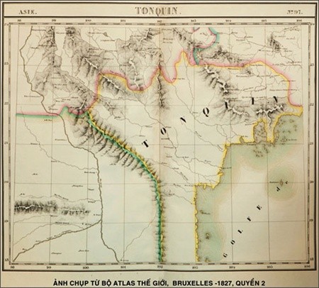
Photo taken from the 1827 World Atlas Bruxelles. The World Atlas Bruxelles which has been judged by the French and Belgian historians as the high scientific and legal value in affirming the undeniable sovereignty of Vietnam over the Hoang Sa (Paracel) and Truong Sa (Spratly) archipelagoes.— File Photo
|
After taking power, Nguyen kings expressed a consistent thinking about the national sea and islands. History books in Chinese and Chinese-transcribed Vietnamese recorded Vietnam’s exercise of sovereignty over territorial waters, particularly over the Truong Sa and Hoang Sa archipelagoes. An 1881 book summarizing the most easily understandable things for children is one example. This is a textbook written in lines of 4 words, describing important individuals, historic dates, and facts of astronomy and geography. There is a map in the book above a brief description of Vietnam’s borders. The map labels Vietnam’s territorial waters, including Hong Dam, a number of islands in the Tonkin Gulf, and Hoang Sa archipelago, in addition to mainland place names. Associate Professor Nguyen Ta Nhi of the Institute of Han Nom Studies further explained to VOV: “The book is a summary of the most basic, easily understood things children need to know about social issues. Both adults and children should be aware of Vietnam’s territorial sovereignty. The book was written by a scholar from Kim Giang, now Hanoi, in 1881. It was a time when books for children in China acknowledged that China’s border ends at Hainan Island.”
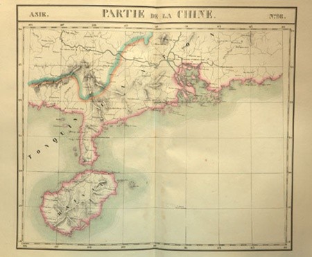
The professor Ngoc affirms that in spite of studying many old international maps relating to Hoang Sa and Truong Sa, this atlas was one of the invaluable maps affirming Vietnam's indisputable sovereignty over the two archipelagoes.— Photo thanhien
|
History books in Chinese-transcribed Vietnamese provide historical knowledge that includes accurate data about Vietnamese territorial sovereignty through different dynasties. This is clear evidence refuting China’s claim that its documentation of sea and island sovereignty date back 2,000 years. Associate Professor Trinh Khac Manh, a former Director of the Institute of Han Nom Studies, said: “According to Chinese maps printed in the early 20th century, China’s border ends at Hainan Island. I also have a 1912 Chinese primary school textbook with a map showing that China’s border ends at Hainan Island.”