(VOVworld) - If you want to draw the map of Vietnam, your first stroke might well be cape Sa Vi in Mong Cai city, Quang Ninh province. They call this place Sa Vi because, at each low tide, the receding water leaves a wide strip of sand in the shape of a dragon’s tail. “Vi” means tail and “Sa” means “sand”. Today Discovery Vietnam will take you on a tour of Sa Vi.
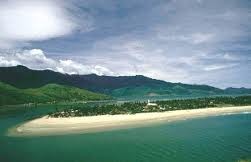
Sa Vi cape- Photo: anbinhtravel.com
The sun rises behind the fog and we leave the town of Mong Cai. After a few kilometers, we arrive at Sa Vi, leaving behind the village of Tra Co, its communal house and its church. A sign marking the Vietnam-China board greets us. On the signboard is a poem by revolutionary poet To Huu, which says "From Tra Co’s casuarina forests to Ca Mau’s mangrove forests”. The Tra Co border guards wave to us. Captain Ho Van Tong, our guide, has been working at this border station for 8 months. He has now become a professional tour guide for the region.
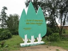
On the signboard is a poem by revolutionary poet To Huu, which says "From Tra Co’s casuarina forests to Ca Mau’s mangrove forests”. Photo: thethaovanhoa.vn
|
"We are standing at the estuary of Bac Luan (Bei Lun) river which marks the border with China. In front of us are the two border markers between Vietnam and China, number 1377 and 1378. Over there is the village of Zhu Shan in the Chinese city of Dong Xing. To our right is cape Bach Long of Fang Cheng port in China’s Guang Xi province. You see, our fishermen there seriously respect the agreements signed between Vietnam and China", said Tong.
Captain Tong says he admires the natural setting in Sa Vi: "The waves rise so far. Sometimes, when the sea is rough, we feel the wave spray up at our post. The sea is quite calm when the tide is low, but it becomes dangerous when the tide rises. The conditions here are extreme: in summer the wind blows strongly and in winter it is very cold. The rains come very quickly. See! In a wink, the sky is loaded with heavy clouds”.
Just as Tong ends his explanation, a storm descends on us. One of these storms can destroy everything in its path, except casuarinas. They resist all intemperance of the weather. In the rain, the captain is still enthusiastically telling about his favorite moment of the day: sunrise in Sa Vi. "It's wonderful to see the sunrise in Sa Vi. It is a privilege for us to be in this place. I have the opportunity to contemplate the sunrise and I couldn’t see such a sight anywhere else. I am excited every time. It motivates me in my mission. I am ready to do anything to defend our national sovereignty. You know that this place has been the source of inspiration for many filmmakers, writers, and even journalists", said Tong.
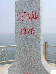
Border marker 1378- Photo: otofun.com |
After the rain, the sky turned suddenly bright, and the sea calmed down. We see the first fishing boasts returning to port. It's time for Ho Van Tong to leave us and go to work. Before leaving Sa Vi, we visit the garden where State leaders plant a tree each time they visit. We go closer to the beach to listen to the sound of the waves and imagine a time hundreds of years ago, when fishermen from Do Son, Hai Phong, arrived here to set up this small fishing paradise.
Hoa Phuong Anh