


 |
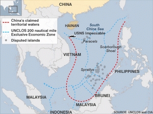
| China’s irrational U-shaped line encroaches a large area of Vietnamese territorial waters |
(VOVworld) – Recently, China has persistently touted its U-shaped line without providing any legal justifications. This line claims as China’s territorial waters most of the East Sea, including Vietnam’s Hoang Sa/ Parcel and Truong Sa/ Spratly Archipelagoes. ASEAN countries and others in the international community have weighed in on the issue. VOV’s editor Anh Huyen comments.
On Sunday, a group of Chinese and Taiwanese scholars held a seminar to discuss the so-called U-shaped line which contains most the East Sea including Vietnam’s Paracel and Spratly Archipelagoes. The scholars suggested the Chinese government choose more persuasive historical materials to argue for China’s territorial claims there. They also proposed that Chinese and Taiwanese oil and gas companies increase cooperation to explore the natural resources around Vietnam’s Spratly islands. This is an illegal act which ignores international laws and the Declaration on Conduct of the Parties in the East Sea to which China is a signatory. It’s obvious that if China has legal evidence, it doesn’t need to look for what they call persuasive historical materials. In an interview with a Chinese newspaper, Director of China’s Nanhai Research Institute Wu Shicun has admitted that the rationalization of Beijing’s territorial claim over the East Sea is based solely on Chinese law, but not adducing any articles of international law. This seminar conveniently ignores the fact that Vietnam has internationally-recognized sovereignty over the Hoang Sa and Truong Sa Archipelagoes.
Most people around the world seem to agree with the stance of Vietnam and ASEAN to use international law to resolve any conflict. The suggestions of the Chinese and Taiwanese scholars go against the common opinion.
A number of international conferences have been held to oppose China’s claim. Vrije University Brussels in Belgium said the U-shaped line is no legal evidence for claiming maritime sovereignty. According to the UN international hydrographic organization, there are no scientific or hydrographic symbols on China’s ‘cow tongue line’ map. Professor David Scott of Brunel University in the UK said that when China submitted the map to the UN, it was aiming to legalize the name of the territorial waters it is claiming. But at the same time, China has failed to give any technical evidence on how the map was drawn, to abide by the UN Convention on the Law of the Sea and let the conflict be resolved under an international jurisdiction. Professor Monique Chemillier Gendreau of the Paris Diderot University in France has said the only explanation of China’s behavior is that it can’t provide any scientific or legal evidence. In other words, it doesn’t have a lag to stand on. Professor Gendreau cited current international law which says a nation can only claim sovereignty over an island if the island has existed under its jurisdiction for a long time and an administrative system has been established there. In fact, in the 1930s the Chinese administration was still confused about the Truong Sa archipelago, and did not mention it on its national map. On the other hand, Vietnamese kings established a land registration agency to govern the Hoang Sa archipelago in the 17th century. This means that in terms of legal documents and verifiable evidence, Vietnam’s materials are more persuasive. Professor Kishore Mahbubani, Dean of Lee Kuan Yew School of Public Policy worries that China’s stance could damage 20 years of efforts to build good will with ASEAN. He even called China’s sending its U-shaped line claim to the UN in 2009 ‘unwise’.
Anh Huyen