As rescue calls flooded every online platform, one young IT engineer stayed awake, watching the night unravel on her screen. Mai Anh realized that social media was overflowed with desperate messages: “Our house is under water,” “Elderly people trapped,” “We need help on the rooftop.”
“The information was chaotic and getting lost. So around 11 pm, I contacted my friend, Tat Huan, who had built a traffic app, and we decided to quickly adapt it as a rescue information platform. We worked from 11 pm to 3 am and launched thongtincuuho.org. It was an emergency situation, and we couldn’t wait,” Mai Anh said.
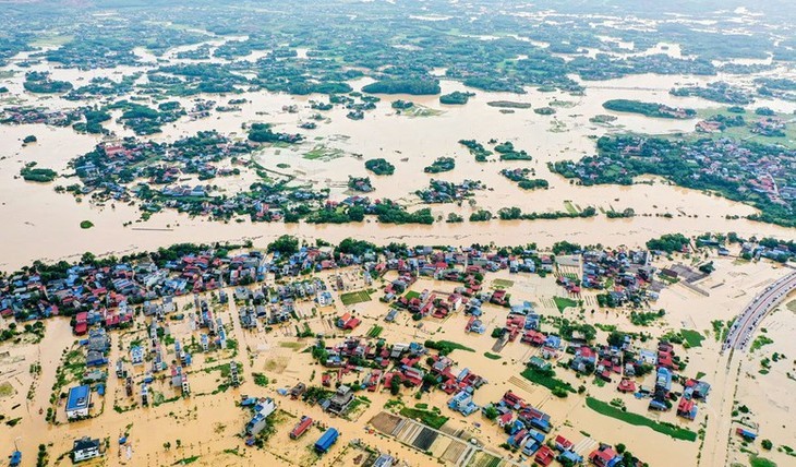 Rain is forecast to continue in Thai Nguyen province. (Photo: VGP) Rain is forecast to continue in Thai Nguyen province. (Photo: VGP) |
Within minutes, Mai Anh’s message reached her teammate Tat Huan, someone who shared her urgency and technical orientation. What followed was a spontaneous act of teamwork. Huan told VOV: “It was already past 11 pm. I was about to go to bed when Mai Anh’s message came: ‘Hey Huan, Thai Nguyen is in a critical situation. Can you help?’ When I saw the rescue posts she sent, I was stunned. So many people were trapped, cut off, and out of power. My feeling at that moment was that I couldn’t sit still. I just acted immediately, without thinking twice.”
That spontaneous decision, made by two young engineers, Mai Anh, an IT engineer with ten years of experience in AI, big data, and automation, and Tat Huan, the developer behind a popular traffic app, gave birth to one of the most remarkable grassroots tech efforts Vietnam has seen in recent years: a real-time digital map for rescue operations.
“Speed was everything. We had only a few hours, only two people, and limited rescue operation experience. Our rule was simple: keep it simple and reuse what we already have. The first version didn’t need to be perfect. It just needed to work,” Mai Anh said.
They began coding in silence, connected only through chat messages and shared urgency. One worked on the data, the other on the map. There were no plans, no design documents, just an understanding that every minute lost could mean another family waiting in the dark.
“I handled the technical setup and map display, while Mai Anh took charge of collecting and extracting data from social media posts and comments. We worked almost in sync; whenever one part was done, the other tested it right away. There was no process or protocol, only trust and the pressure of knowing that every minute mattered,” Tat Huan again.
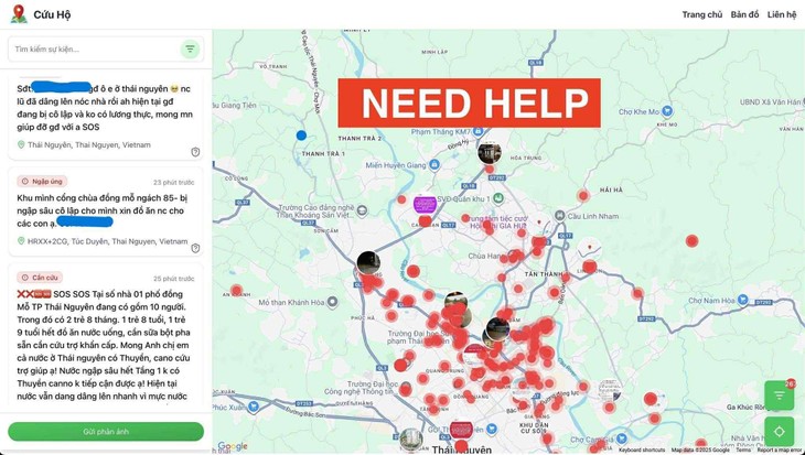 Before dawn, thongtincuuho.org went live and quickly went viral among rescue forces Before dawn, thongtincuuho.org went live and quickly went viral among rescue forces |
Before dawn, thongtincuuho.org went live and quickly went viral among rescue forces. Within hours, hundreds of red pins appeared on the map, each representing a call for help.
“When the first red dots appeared, I felt a mix of relief and fear. Relief because it worked, we could finally visualize where people needed help. But fear, because each dot was a person, a home, a cry for rescue. There were so many of them.”
Homes submerged, roads cut off, families stranded. Volunteers and local authorities began using the map to locate people in danger and coordinate rescue routes. Within hours, the map began to spread across online communities.
But as more users accessed the site, a new challenge surfaced. On the first day alone, Google Maps charged the team over 300 dollars in server fees. A few days later, support arrived from the Vietmap platform and US content delivery company Cloudflare. Their assistance allowed the rescue platform, whose backbone was a combination of artificial intelligence and human verification, to stay online through the critical days of flooding.
Mai Anh said: “Collecting and filtering information from social media comments was really hard. We used AI to cover about 80%, including extracting locations, categorizing needs, and removing duplicates. But we still needed volunteers to manually check everything, like verifying addresses, confirming real situations, and keeping information updated. Actually, more users made us more worried because it meant more people needed help. We just wanted the number on the map to drop to zero as soon as possible”
 The core team includes Mai Anh Nguyen, Tat Huan, and Long Dang The core team includes Mai Anh Nguyen, Tat Huan, and Long Dang |
As floodwaters in Thai Nguyen began to recede, the team barely had time to rest. New alerts were already coming in from nearby provinces. Tat Huan again: “Right after Thai Nguyen situation stabilized, our team received support from engineer Long Dang and started expanding to Bac Giang, Bac Ninh, Lang Son, and then Hanoi. After that update, whenever a province needed assistance, it took us only about five minutes to adapt the system and deploy it. I think what really kept us going was our spirit. During that entire week, the team slept only three to four hours a day, and I could feel everyone’s exhaustion, especially since we all still had our regular jobs in the daytime. No one complained. We all knew we had to stay strong. That shared determination was what mattered most, because without it, the project might have stopped halfway.”
That determination also shaped their vision for what came next. From a one-night emergency fix, the platform began to take on a larger purpose – not just to respond to floods, but to prepare for the next ones. The goal was to create a flexible system that local authorities and volunteers could adapt to their own conditions, whether for floods, landslides, or other emergencies.
Three weeks later, that challenge arrived sooner than anyone expected. In central Vietnam, torrential rains pounded Hue and neighboring provinces for days. The city’s usual calm was broken by the wailing of flood alarms echoing through the ancient streets.
On the afternoon of October 26, four warning sirens across Hue were activated simultaneously, a rare event signaling that an emergency was imminent. Water rose faster than many could escape. Roads disappeared beneath murky torrents; electricity flickered out. Severe flooding paralyzed the North–South railway line, forcing Vietnam Railways to suspend trains between Hanoi and Ho Chi Minh City. More than 306,000 households and businesses in Hue, Da Nang, and Quang Tri were left without power.
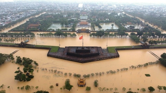 Hue Citadel relic site is submerged in floodwater. Photo: VGP Hue Citadel relic site is submerged in floodwater. Photo: VGP |
This time, however, help was coming, not just from teams on the ground, but from the network that was born on that stormy night in Thai Nguyen. Tat Huan said: “On October 26, as the situation in Hue, Da Nang, and Quang Nam started to worsen, our team held an emergency meeting to gather and process data. By October 28, the system had handled nearly 1,000 rescue requests from those areas. Our goal has always been simple –to help everyone, from citizens to rescue teams, quickly visualize where help is most needed. The map allows rescuers to identify hot zones and coordinate their routes more effectively.”
On the digital map, red pins once again began to appear, this time not in Thai Nguyen, but in Hue, hundreds of kilometers to the south. On Monday, rainfall in Hue totaled 1,085 mm in 24 hours, the highest volume of rainfall ever recorded in Vietnam, according to the National Center for Hydro-Meteorological Forecasting.
For the team behind the map, those dots were not just data points, they were voices waiting to be heard. As flooding spread through Hue and the central region, new calls poured in every minute. Through sleepless nights providing urgent updates, what kept them going, Mai Anh said, was something deeper than technology.
“We can keep this project running for the short term, but for the long term, we need more support and cooperation. Technology isn’t the hardest part. The real challenge is operations and human resources. We need people who have real expertise in rescue work, and a volunteer network that’s ready to act. Sometimes it’s best just to start. When people need help, you just do it,” Mai Anh again.
That spirit of action, of simply stepping up when help is needed, is what Tất Huân and his team are building on. Tat Huan said: “The rescue map grew out of our traffic platform, vntraffic.app. Right now, we’re developing both systems in parallel and preparing to release mobile versions on iOS and Android. The goal is to help people move more intelligently and safely, not only in daily traffic but also in emergencies. We’re also exploring ways for users to send rescue information directly through the app, so it can be used in disasters, epidemics, and other crises.”
As the waters in Hue slowly receded, long convoys of relief trucks began rolling in from across the country. Among them were vehicles from Thai Nguyen, the same province that, weeks earlier, had cried out for help under the red flare of an SOS. What began as a single night of sleepless coding has grown into something larger, a network of empathy and innovation. In every disaster, there are those who run toward the danger, driven not by duty but by compassion. On a map dotted with red pins and green dots, you can see the compassion of young engineers that created it.