


 |
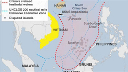
| The U-shaped line on the map drawn by China. (Photo: VOV). |
(VOVworld) – A VOV correspondent in Beijing has quoted Xue Litai, a well-known Chinese academic and commentator, as saying that the territorial dispute between Vietnam and China in the East Sea has recently become seriously strained. In an article published in Hong Kong’s online newspaper Fenghuang last Friday, Xue wrote that the conflict became more complicated when the China National Offshore Oil Corporation invited international bids for exploration and production at nine oil and gas blocks. Xue said that although they are situated east of the U-shaped boundary, they are completely within Vietnam’s exclusive economic zone and continental shelf, in accordance with the 1982 United Nations Convention on the Law of the Sea. The Chinese academic said that it will be difficult for China to explain and persuade the international community to recognize the U-shaped line as its national border and may face the following challenges:
First, the Government of China originally drew 11-dotted boundaries on its land map but did not conduct demarcation of its maritime boundaries with neighboring countries or did anything to receive international recognition. Meanwhile, in international law, there have been no explanations about these claims.
Second, to date, China has not clarified whether the U-shaped line is a cut national border or traditional maritime boundaries. China has not defined the line or stated the longitudes and latitudes. As China has simply drawn the cut lines on its map, it will be hard to persuade others.
Third, if Beijing claims the 11-dotted-line is an un-deniable national border, why did the Government of China, as soon as it was formed, change the boundaries by removing two dashes in the Tonkin Gulf on the map without giving any reasons? Is it a way of China showing its love to Vietnam or China seeing the correction of the national borders a joke?
Fourth, according to Xue, if Beijing claims the 9-dotted line as its national boundary, why hasn’t Beijing mentioned the East Sea issue in its diplomatic dealings with Vietnam over the past 30 years, since Vietnam was united in 1975? As during that period, Vietnam continuously occupied 30 islands. This is very unusual.
Finally, the East Sea contains strategic shipping lanes for more than 80% of cargo to North East Asia, including Japan, the Republic of Korea, and 40% of the commodities in Western countries. Therefore, it is not an exaggeration to say that the East Sea is vital for Western nations.
If the 9-dash-line is declared China’s claim is upheld, and the US and its allies want to transport military forces between the Pacific Ocean and the Indian Ocean, they could be considered to be in an illegal area and could be impeded. In that scenario, will the international community accept China’s declaration?